|
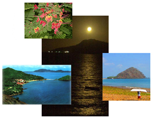
Tropical
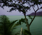
climates have a wet season and a dry season, and Isla Taboga is no exception.
Although it rains more on Panama's mainland than on Isla Taboga, the rainy
season starts in May and builds through November. There's an old
saying in Panama, "The rain ends on 15 December," and that's literally
true. From 15 December through April, the skies are clear and sunny.
It's a dependable paradigm.
The
months of January through April are the tourist months of Isla Taboga.
Many visitors a day from Panama and abroad come to Isla Taboga to bathe
in its clear, clean tropical waters and walk its winding paths of the pristine
town of San Pedro and to reflect on its long history. |
.
| Panama's
cycle of rainfall is determined primarily by two factors: moisture from
the Caribbean, which is transported by north and northeast winds prevailing
during most of the year, and the continental divide, which acts as a rainshield
for the Pacific lowlands. Panama's Pacific side, therefore receives
less rainfall than its Atlantic side. |
|
|
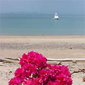
Vegetation
As
in any tropical climate, the flora of Isla Taboga is a stunning display
of nature's vitality. The lianas, bromeliads, orchids, ferns, and
fruit trees are typical of the lush, perennial rainforest that exists throughout
much of the island. Isla Taboga's expanse of rainforest is interrupted
only in the town of San Pedro where nature's gifts are cultivated and domesticated.
The island boasts the nickname of |
"The Island
of Flowers," and that it is. Nisperos, mameyes, nance, mango, tamarind,
and the island's pineapples, world famous for their sweetness, are grown
for the beautification of the town and the utter enjoyment of visitors.
.
 |
Tides
The
Gulf of Panama is extraordinarily shallow, where depths of 500 feet are
reached only outside its perimeter. A variation of about 1 to 2 feet
between high and low tides exist on the Caribbean coast, which contrasts
sharply with 16 foot tides on the Pacific side. Tides on Isla Taboga
range from 11 to 18 feet.
There
is a marked contrast between high tide and low tide on Isla Taboga.
At high tide, the sand bar that joins Isla Taboga's offshore island, El
Morro, is submerged in 4 feet of water. Low tides expose a rocky
shoreline in some places, and in others, a wide, white sand beach is exposed.
There are two tidal changes per day on Isla Taboga. |
.
Water
Depth
Isla
Taboga's small bay in front of the town of San Pedro and Playa Honda reaches
depths of 40 to 60 feet offshore. The water offshore from Playa Restinga
is much shallower at 10 to 20 feet. A third bay, Bahia Noreste, located
on Isla Taboga's northeastern side, also reaches depths of 40 to 60 feet.
Isla Taboga's offshore depths offer safe anchorage for any size vessel.
 |
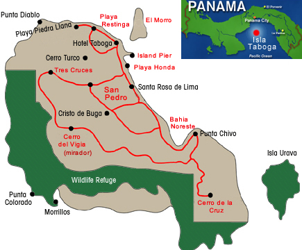
Relief
Isla
Taboga and the other five islands in the immediate vicinity are of volcanic
origin, having formed some 2 million years ago when the earth's crust rose
to connect North and South America. It is a relatively new landscape
on the geologic timescale.
Panama
and Isla Taboga do not have earthquakes. Unlike Costa Rica to the
northwest and Colombia to the southeast, Panama lies well away from the
margins of tectonic activity that have reeked havoc in almost every other
country in the region. Age old buildings and modern skyscrapers attest
to Panama's safe location. |
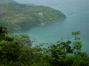
Isla
Taboga is approximately 12 miles from the mainland of Panama, and the brightly
lit skyline of Panama City can be easily observed at night anywhere on
the island. The juxtaposition of the quaint pueblo of San Pedro on
Isla Taboga allows for spectacular sunrises over the Bay of Panama.
At night, the moon rises over the waters, allowing all the ambiance of
full romance.
Isla
Taboga's coastal perimeter is about 8 miles long. There are three
mountain peaks of modest height. El Vigia (the watchtower) is the
highest at almost 1200 feet. At the top of El Vigia is an old U.S.
Army gun emplacement that's been converted to a mirador with a panoramic
view of the Pacific Ocean and surrounding islands. On clear nights,
stargazers are treated to a brilliant southern sky that often reveals both
the Big Dipper and Southern Cross.The next highest peak is Cerro de la
Cruz, the site of a 20 foot cross that dates back to the founding of the
island in 16h century.
 |
The
southern length of Isla Taboga is steep faced and barely accessible except
by boat. This part of the island has been designated a national protective
habitat for the migrating Brown Pelican that makes it its home once a year.
The
waters of this part of the Pacific Ocean are the home of some of the best
sport fishing in the world. Black Marlin, Blue Marlin, Pacific Sailfish,
Yellowfin Tuna, Roosterfish, Wahoo, Cubera Snapper, Corvina, and Amberjack,
just to name a handful. Isla Taboga is a fishing town. Everybody
on the island over the age of 15 can be your guide to some of the best
fishing in the world. |
.
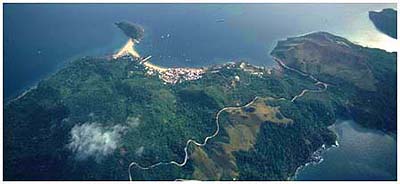
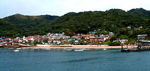
| The
northern shore of Isla Taboga is the site of the picturesque town of San
Pedro and the first port on the Pacific Ocean in the New World. Panama
City was the first town on the Pacific Coast, but its offshore topography
and tidal variations prevented it becoming a port. Isla Taboga was
better sited. It's a well known historical fact that Pizzaro used
Isla Taboga's wood to build the ships he used to conquer the Incas in 1539.
The historical ruins in the town of San Pedro were once inhabited by Pizzaro. |
|
.
Today,
the town of San Pedro has less than 1000 inhabitants. Its streets,
better named paths, wind in a seemingly endless maze among the 256 dwellings
on the island. Taboganos make their living from the ocean, and all
are seafarers. Aside from several golf carts used by weekend homeowners
from Panama City, the island has three small trucks used for everything
from carrying islander belongings to and from the ferry to hauling cargo
and building supplies to carrying passengers to the top of El Vigia.
The rest of the island walks. The town of San Pedro is so small,
you are never more than 5 minutes from anywhere else.
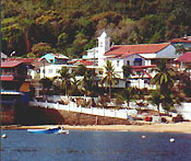 |
The
center of San Pedro is the town plaza, the site of the second oldest church
in the hemisphere. Like any plaza in any Latin American pueblo, the
plaza on Isla Taboga is the place where people of all ages congregate to
talk, play games, or just sit and relax. The plaza is also the site
of the many festivals that occur on Isla Taboga. They are a time
of family reunions and a chance for Panamanians and tourists to get away
from it all and enjoy the provincial celebrations. Whether the rainy
season or the tourist season, Isla Taboga is a place special to the hearts
of all those who visit its shores. |
|